

Sectional Charts
The VFR sectional is your primary navigation reference — terrain, airspace, airports, obstacles, frequencies, and magnetic variation are all encoded on a single page. The CPL standard adds chart-currency discipline and the ability to extract MEFs and airport details in seconds. Reference: FAA Aeronautical Information Services — VFR charts and the FAA Chart User's Guide.
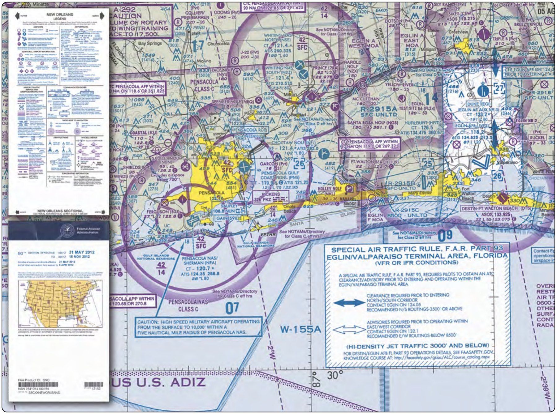
Scale & currency
- Scale: 1:500,000 — 1 inch ≈ 7 nautical miles. The Terminal Area Chart (TAC) at 1:250,000 is double-resolution and used inside Class B veils.
- Currency: Sectionals are revised every 56 days. Always verify the effective date before flight — out-of-date charts may miss new airspace, towers, or frequency changes.
- Download current digital sectionals free at FAA AeroNav; ForeFlight and SkyVector mirror them.
- The FAA Chart User's Guide is the canonical legend reference — bookmark it.
Terrain — contours & MEF
- Contour lines show terrain elevation. Standard interval is 500 ft, with intermediate 250 ft contours in flatter areas.
- Maximum Elevation Figure (MEF) — the bold magenta number in each lat/long quadrangle. Gives the highest terrain or obstacle in that quadrangle, rounded up plus a buffer (varies by AGL height of the highest feature). Use it for minimum safe altitude planning.
- Color-shaded relief: green = low terrain, yellow/tan/brown = increasing elevation. Mountainous areas show more pronounced shading.
- Obstacles: black symbols with elevation in MSL (top number) and AGL (parenthesized number). Lit obstacles show a small lightning-bolt symbol.
Airport symbology
- Color codes the controlling agency:
- Blue = airport with operating tower (controlled, has a published CT- frequency)
- Magenta = uncontrolled airport (CTAF/UNICOM only)
- Shape encodes runway info: circle = no hard-surface runways or smaller layout; runway pattern = the runway configuration (depicted to scale ≥ 8,069 ft).
- Star = rotating beacon operates sunset to sunrise.
- Box "R" = AWOS, ASOS, or other automated weather observation. Frequency listed nearby.
- "Pvt" = private use airport, no public ops without permission.
- Airport data block lists: name, identifier, elevation MSL, lighting, longest runway, CTAF/tower freq.
For the full symbology table, see the FAA Chart User's Guide §1 (VFR).
Magnetic variation — isogonic lines
- Isogonic lines are dashed magenta lines labeled with degrees east or west — they connect points of equal magnetic variation (the angular difference between true north and magnetic north).
- "East is least, West is best" — east variation is subtracted from true course to get magnetic course; west variation is added.
- Variation drifts over time as Earth's magnetic poles move. The chart's stated variation is current as of publication; the FAA reissues charts as variation changes meaningfully.
- Agonic line — the line of zero variation, currently running roughly through the central US (varies year to year). On either side, variation grows.
Airspace depiction quick-reference
- Class B: solid blue lines, "wedding cake" shelf altitudes labeled (e.g., "100 / SFC" = 10,000 MSL ceiling, surface floor)
- Class C: solid magenta lines, two concentric rings, altitudes labeled the same way
- Class D: dashed blue lines, ceiling labeled in a blue-bordered box (e.g., "[25]" = 2,500 MSL ceiling)
- Class E starting at 700 AGL: magenta vignette (faded magenta border)
- Class E starting at 1,200 AGL: blue vignette (faded blue border on the Class G side)
- Class G: below the vignette, no special outline
- Special-use airspace: see Special-Use Airspace — restricted, prohibited, MOA, warning, alert
Full detail on each class is on the Airspace sub-page.